

(Download a higher resolution picture by clicking on any
picture below.) 
I overindulge my fascination with flying machines. I also love to tour the California desert. Something I like to do a lot is to go see airplanes flying around the desert. Airplanes that are working, conducting the business of testing and training. Away from the airports and airshows. Airplanes in the wild.
The Mojave desert is the site of nearly continuous military aircraft operations. The R-2508 Restricted Airspace Complex stretches from Bishop to Edwards Air Force Base and from Tehachapi to the Nevada State line. Approximately 18,000 low level test and training missions are conducted within the R-2508 Complex annually.
Under the R-2508 Complex, the Saline Valley, adjacent to Death Valley, is used by military aircraft to transit between China Lake NAWC, Edwards AFB, and test ranges in Nevada. Aircraft from Fresno ANG Station and Lemoore NAS aircraft use the area for training. They can all be observed while sitting in a naturally fed hot spring.
This is the X-15A-2,
piloted by Pete Knight  , shortly
after launch on its fifty-third flight on October 3,1967. It had
been launched from the NB-52B over Mud Lake in Nevada at an
altitude of 45,000 feet. On this flight it achieved the highest
speed of any aircraft except the space shuttle, 4,520 miles per
hour. On that flight it flew directly over the Racetrack Playa at
about 100,000 feet going mach 6. If you had been sitting in the
source spring on that october morning, the rocket plume of the
hypersonic spaceplane would have been clearly visible streaking
across the sky, twice as fast as an SR-71A Blackbird. Shortly
afterward, the sonic boom would have echoed back and forth within
the valley walls. (Photo courtesy Edwards Air Force Base History
Office)
, shortly
after launch on its fifty-third flight on October 3,1967. It had
been launched from the NB-52B over Mud Lake in Nevada at an
altitude of 45,000 feet. On this flight it achieved the highest
speed of any aircraft except the space shuttle, 4,520 miles per
hour. On that flight it flew directly over the Racetrack Playa at
about 100,000 feet going mach 6. If you had been sitting in the
source spring on that october morning, the rocket plume of the
hypersonic spaceplane would have been clearly visible streaking
across the sky, twice as fast as an SR-71A Blackbird. Shortly
afterward, the sonic boom would have echoed back and forth within
the valley walls. (Photo courtesy Edwards Air Force Base History
Office)
Saline Valley, March 24, 1997 |
 F/A-18B of VA-122 out of Lemoore
NAS dives into the Saline Valley. Photographer: Brian Lockett.
F/A-18B of VA-122 out of Lemoore
NAS dives into the Saline Valley. Photographer: Brian Lockett.
 F/A-18B maneuvering over the Saline
Valley dunes. Photographer: Brian Lockett.
F/A-18B maneuvering over the Saline
Valley dunes. Photographer: Brian Lockett.
 As they fly over the camp, the
pilots of this F/A-18B may be taking a gander at the occupants of
the hot spring. Photographer: Brian Lockett.
As they fly over the camp, the
pilots of this F/A-18B may be taking a gander at the occupants of
the hot spring. Photographer: Brian Lockett.
 F/A-18B seen against the backdrop
of McEvoy Canyon in the Inyo Mountains. There is a spring in the
wall of the canyon that supports a lush growth of ferns and
provides a cool, wet environment thats great for getting out of
the wind and heat. Photographer: Brian Lockett.
F/A-18B seen against the backdrop
of McEvoy Canyon in the Inyo Mountains. There is a spring in the
wall of the canyon that supports a lush growth of ferns and
provides a cool, wet environment thats great for getting out of
the wind and heat. Photographer: Brian Lockett.
 F/A-18B cruises at low altitude up
the Eureka-Saline corridor. The mountain building that is going
on around the valley is so rapid that headward erosion hasn't
reached the top of the recently (last several million years)
exposed surface of the mountains. Photographer: Brian Lockett.
F/A-18B cruises at low altitude up
the Eureka-Saline corridor. The mountain building that is going
on around the valley is so rapid that headward erosion hasn't
reached the top of the recently (last several million years)
exposed surface of the mountains. Photographer: Brian Lockett.
 This E-8A J-STARS cruised over the
valley in a racetrack pattern for several hours. The radar in
this airplane could determine the position, direction of travel,
and speed of every vehicle in Death Valley National Park
simultaneously. It has something like eighteen computer stations,
each with a half gigabyte of RAM. It has been reported in
Aviation Week that the computing power of one J-STARS is greater
than the entire E-3 Sentry fleet. Photographer: Brian Lockett.
This E-8A J-STARS cruised over the
valley in a racetrack pattern for several hours. The radar in
this airplane could determine the position, direction of travel,
and speed of every vehicle in Death Valley National Park
simultaneously. It has something like eighteen computer stations,
each with a half gigabyte of RAM. It has been reported in
Aviation Week that the computing power of one J-STARS is greater
than the entire E-3 Sentry fleet. Photographer: Brian Lockett.
 F-15B of the 6512 Test Squadron
based at Edwards AFB flies directly over my campsite.
Photographer: Brian Lockett.
F-15B of the 6512 Test Squadron
based at Edwards AFB flies directly over my campsite.
Photographer: Brian Lockett.
 F-15B cruises toward the Inyo
Mountains. Photographer: Brian Lockett.
F-15B cruises toward the Inyo
Mountains. Photographer: Brian Lockett.
Early in the morning,  a North
American QF-86F Sabre from China Lake NWC cruises around the
Saline Valley in March 1988. Photographer: Brian Lockett.
a North
American QF-86F Sabre from China Lake NWC cruises around the
Saline Valley in March 1988. Photographer: Brian Lockett.
Palm Spring is down on that white  patch
of clay, which is being buzzed by a McDonnell Douglas F/A-18
Hornet. Photographer: Brian Lockett.
patch
of clay, which is being buzzed by a McDonnell Douglas F/A-18
Hornet. Photographer: Brian Lockett.
McDonnell Douglas  F/A-18
Hornets are among the most common aircraft in the valley.
Photographer: Brian Lockett.
F/A-18
Hornets are among the most common aircraft in the valley.
Photographer: Brian Lockett.
I had climbed  to the top
of a ridge of the Saline Range near the spring with a friend when
a
to the top
of a ridge of the Saline Range near the spring with a friend when
a  Gruman F-14A spotted us and
proceeded to make a series of passes over our position.
Photographer: Brian Lockett.
Gruman F-14A spotted us and
proceeded to make a series of passes over our position.
Photographer: Brian Lockett.
The Edwards Air Force Base high speed corridor runs close to
the town  of
Rosamond. A General Dynamics F-106 Delta Dart chase is tailing a
Rockwell B-1B Lancer around the Antelope Valley in April of 1988,
the afternoon before the airshow at the China Lake NWC.
Photographer: Brian Lockett.
of
Rosamond. A General Dynamics F-106 Delta Dart chase is tailing a
Rockwell B-1B Lancer around the Antelope Valley in April of 1988,
the afternoon before the airshow at the China Lake NWC.
Photographer: Brian Lockett.
The Panamint Valley is also used for military aircraft  operations. Signs warn of the
possibility of sonic booms in the valley. Here a McDonnell
Douglas RF-4B from China Lake NWC flies near the ghost town of
Ballarat the morning after the Edwards AFB Airshow of 1988.
Photographer: Brian Lockett.
operations. Signs warn of the
possibility of sonic booms in the valley. Here a McDonnell
Douglas RF-4B from China Lake NWC flies near the ghost town of
Ballarat the morning after the Edwards AFB Airshow of 1988.
Photographer: Brian Lockett.
A McDonnell Douglas F-15 Eagle  is seen
against the Inyo Mountains early on an October morning in 1988.
Photographer: Brian Lockett.
is seen
against the Inyo Mountains early on an October morning in 1988.
Photographer: Brian Lockett.
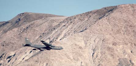
 Boeing B-52G
  from the 320th Bomb Wing out of
  Mather AFB flies by Palm Spring on a
low level mission through the Saline Valley in October 1988.
Photographer: Brian Lockett.
Mather AFB flies by Palm Spring on a
low level mission through the Saline Valley in October 1988.
Photographer: Brian Lockett.
 A moment after the B-52G above had
flown past, B-52G, Serial 58-0183,
also from the 320 BW at Mather AFB flew almost directly overhead.
Rack adapters for conventional iron bombs can be seen on the
weapons pylons. The small pylon between the engine pylons is for
ALE-25 forward firing chaff rockets. It has a california black
bear squadron insignia painted on the vertical stabilizer.
Photographer: Brian Lockett.
A moment after the B-52G above had
flown past, B-52G, Serial 58-0183,
also from the 320 BW at Mather AFB flew almost directly overhead.
Rack adapters for conventional iron bombs can be seen on the
weapons pylons. The small pylon between the engine pylons is for
ALE-25 forward firing chaff rockets. It has a california black
bear squadron insignia painted on the vertical stabilizer.
Photographer: Brian Lockett.
Grumman A-6E  Intruder
makes a late afternoon run through the Saline Valley in October
1988. Photographer: Brian Lockett.
Intruder
makes a late afternoon run through the Saline Valley in October
1988. Photographer: Brian Lockett.
Vought TA-7C training Corsair of the  "Flying Eagles of VA-122 based
at Lemoore NAS is seen here against the Inyo Mountains in
September 1990. Photographer: Brian Lockett.
"Flying Eagles of VA-122 based
at Lemoore NAS is seen here against the Inyo Mountains in
September 1990. Photographer: Brian Lockett.
McDonnell Douglas TF-18A training Hornet races past  the Saline Range in September 1990.
Photographer: Brian Lockett.
the Saline Range in September 1990.
Photographer: Brian Lockett.
A McDonnell Douglas F/A-18 Hornet Heading up to Steele Pass
and the  Eureka Valley in December 1990.
While you are in the Saline Valley, tune your scanner to 123.95, 256.80, or 322.30. In the Panamint Valley, 120.25 or 291.60. In the Owens Valley, 126.55 or 322.3.
 Link to the In
the Wild index page for more pictures of jets in the
desert.
Link to the In
the Wild index page for more pictures of jets in the
desert.
Go to home page of the Goleta Air and
Space Museum.
Send a message to Brian.